![](/images/other/stat-length.png)
![Tocht Mountainbike La Flèche - La Fleche - Nord Est - Photo](https://media.geolcdn.com/t/1900/400/ext.pjpeg?maxdim=2&url=https%3A%2F%2Fservices.sitytrail.com%2FGeolivesWS%2FDownloadMedia.ashx%3FTrailID%3D118814%26Media%3D13022_1.jpg)
La Fleche - Nord Est
tracegps
Gebruiker
![Lengte](/images/other/stat-length.png)
Lengte
42 km
![Max. hoogte](https://static1.geolcdn.com/siteimages/upload/files/1508320355ic_sort_altitude_max_24dp.png)
Max. hoogte
113 m
![Positief hoogteverschil](https://static1.geolcdn.com/siteimages/upload/files/1508320355ic_sort_den_pos_24dp.png)
Positief hoogteverschil
447 m
![Km-Effort](/images/other/stat-length.png)
Km-Effort
48 km
![Min. hoogte](https://static1.geolcdn.com/siteimages/upload/files/1508320355ic_sort_altitude_min_24dp.png)
Min. hoogte
26 m
![Negatief hoogteverschil](https://static1.geolcdn.com/siteimages/upload/files/1508320355ic_sort_den_neg_24dp.png)
Negatief hoogteverschil
448 m
![Boucle](https://static1.geolcdn.com/siteimages/upload/files/16400158638029165_repeat_loop_refresh_sync_direction_icon.png)
Boucle
Ja
Datum van aanmaak :
2014-12-10 00:00:00.0
Laatste wijziging :
2014-12-10 00:00:00.0
![Mountainbike](https://static1.geolcdn.com/sitytour/trail-icons/202.png)
3h00
Moeilijkheid : Medium
![Scan deze QR-code om de tocht te openen in de SityTrail-applicatie](https://capi.geolives.com/qq0zvz2zws4bq2lad0pu/sitytour/trails/118814/qr.png?size=200)
Gratisgps-wandelapplicatie
Over ons
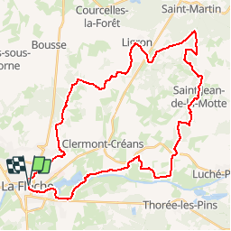
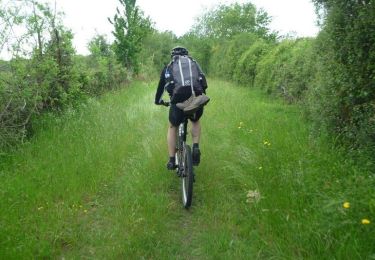
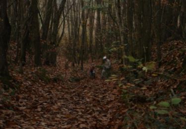
Tocht Mountainbike van 42 km beschikbaar op Pays de la Loire, Sarthe, La Flèche. Deze tocht wordt voorgesteld door tracegps.
Beschrijving
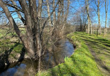
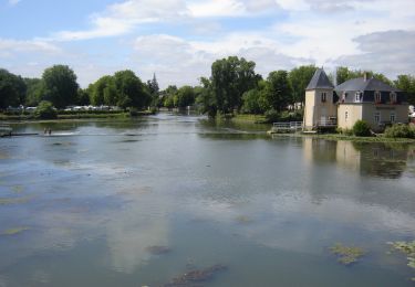
Départ par les bords de Loir (Les 10 premiers km sont faciles et plats) - Zone plus technique sur Saint Jean de la Motte - Très beaux chemins creux sur Saint Germain du Val.
Plaatsbepaling
Land:
France
Regio :
Pays de la Loire
Departement/Provincie :
Sarthe
Gemeente :
La Flèche
Locatie:
Unknown
Vertrek:(Dec)
Vertrek:(UTM)
719647 ; 5286828 (30T) N.
Opmerkingen
Wandeltochten in de omgeving
![Tocht Mountainbike La Flèche - La Flèche Sud - Photo](https://media.geolcdn.com/t/375/260/ext.jpg?maxdim=2&url=https%3A%2F%2Fstatic1.geolcdn.com%2Fsiteimages%2Fupload%2Ffiles%2F1524743154velo.jpg)
![Mountainbike Mountainbike](https://static1.geolcdn.com/sitytour/trail-icons/202.png)
La Flèche Sud
Mountainbike
Medium
(2)
La Flèche,
Pays de la Loire,
Sarthe,
France
![](/images/other/stat-length.png)
46 km | 51 km-effort
3h 15min
![](https://static1.geolcdn.com/siteimages/upload/files/16400158638029165_repeat_loop_refresh_sync_direction_icon.png)
Ja
![Tocht Mountainbike La Flèche - La Flèche - Saumur par les chemins - Photo](https://media.geolcdn.com/t/375/260/ext.jpg?maxdim=2&url=https%3A%2F%2Fservices.sitytrail.com%2FGeolivesWS%2FDownloadMedia.ashx%3FTrailID%3D316964%26Media%3D16084_6.jpg)
![Mountainbike Mountainbike](https://static1.geolcdn.com/sitytour/trail-icons/202.png)
La Flèche - Saumur par les chemins
Mountainbike
Medium
La Flèche,
Pays de la Loire,
Sarthe,
France
![](/images/other/stat-length.png)
88 km | 99 km-effort
5h 0min
![](https://static1.geolcdn.com/siteimages/upload/files/16400158638029165_repeat_loop_refresh_sync_direction_icon.png)
Neen
![Tocht Mountainbike La Flèche - La Flèche - Grande Boucle Sud Ouest - Photo](https://media.geolcdn.com/t/375/260/ext.jpg?maxdim=2&url=https%3A%2F%2Fservices.sitytrail.com%2FGeolivesWS%2FDownloadMedia.ashx%3FTrailID%3D215065%26Media%3D15639_6.jpg)
![Mountainbike Mountainbike](https://static1.geolcdn.com/sitytour/trail-icons/202.png)
La Flèche - Grande Boucle Sud Ouest
Mountainbike
Moeilijk
La Flèche,
Pays de la Loire,
Sarthe,
France
![](/images/other/stat-length.png)
84 km | 96 km-effort
6h 0min
![](https://static1.geolcdn.com/siteimages/upload/files/16400158638029165_repeat_loop_refresh_sync_direction_icon.png)
Ja
![Tocht Mountainbike La Flèche - Tour de la Flèche en 4 Jours - Photo](https://media.geolcdn.com/t/375/260/ext.jpg?maxdim=2&url=https%3A%2F%2Fservices.sitytrail.com%2FGeolivesWS%2FDownloadMedia.ashx%3FTrailID%3D172268%26Media%3D13580_3.jpg)
![Mountainbike Mountainbike](https://static1.geolcdn.com/sitytour/trail-icons/202.png)
Tour de la Flèche en 4 Jours
Mountainbike
Gemakkelijk
La Flèche,
Pays de la Loire,
Sarthe,
France
![](/images/other/stat-length.png)
163 km | 181 km-effort
16h 0min
![](https://static1.geolcdn.com/siteimages/upload/files/16400158638029165_repeat_loop_refresh_sync_direction_icon.png)
Ja
![Tocht Fietstoerisme La Flèche - La Flèche, Luché pringé - Photo](https://media.geolcdn.com/t/375/260/ext.jpg?maxdim=2&url=https%3A%2F%2Fstatic1.geolcdn.com%2Fsiteimages%2Fupload%2Ffiles%2F1524743154velo.jpg)
![Fietstoerisme Fietstoerisme](https://static1.geolcdn.com/sitytour/trail-icons/204.png)
La Flèche, Luché pringé
Fietstoerisme
Gemakkelijk
La Flèche,
Pays de la Loire,
Sarthe,
France
![](/images/other/stat-length.png)
33 km | 35 km-effort
2h 15min
![](https://static1.geolcdn.com/siteimages/upload/files/16400158638029165_repeat_loop_refresh_sync_direction_icon.png)
Neen
![Tocht Mountainbike La Flèche - Nico tout seul très beau temps - Photo](https://media.geolcdn.com/t/375/260/195ac492-309c-4a9f-bfb4-f1b1c36a915d.jpg&format=jpg&maxdim=2)
![Mountainbike Mountainbike](https://static1.geolcdn.com/sitytour/trail-icons/202.png)
Nico tout seul très beau temps
Mountainbike
La Flèche,
Pays de la Loire,
Sarthe,
France
![](/images/other/stat-length.png)
29 km | 32 km-effort
1h 35min
![](https://static1.geolcdn.com/siteimages/upload/files/16400158638029165_repeat_loop_refresh_sync_direction_icon.png)
Ja
![Tocht Mountainbike La Flèche - La Flèche - Grande Boucle Nord Est - Photo](https://media.geolcdn.com/t/375/260/ext.jpg?maxdim=2&url=https%3A%2F%2Fservices.sitytrail.com%2FGeolivesWS%2FDownloadMedia.ashx%3FTrailID%3D215075%26Media%3D15651_2.jpg)
![Mountainbike Mountainbike](https://static1.geolcdn.com/sitytour/trail-icons/202.png)
La Flèche - Grande Boucle Nord Est
Mountainbike
Moeilijk
La Flèche,
Pays de la Loire,
Sarthe,
France
![](/images/other/stat-length.png)
88 km | 101 km-effort
6h 0min
![](https://static1.geolcdn.com/siteimages/upload/files/16400158638029165_repeat_loop_refresh_sync_direction_icon.png)
Ja
![Tocht Mountainbike La Flèche - La Flèche Nord Ouest - Photo](https://media.geolcdn.com/t/375/260/ext.jpg?maxdim=2&url=https%3A%2F%2Fservices.sitytrail.com%2FGeolivesWS%2FDownloadMedia.ashx%3FTrailID%3D118816%26Media%3D13025_1.jpg)
![Mountainbike Mountainbike](https://static1.geolcdn.com/sitytour/trail-icons/202.png)
La Flèche Nord Ouest
Mountainbike
Gemakkelijk
La Flèche,
Pays de la Loire,
Sarthe,
France
![](/images/other/stat-length.png)
35 km | 39 km-effort
2h 30min
![](https://static1.geolcdn.com/siteimages/upload/files/16400158638029165_repeat_loop_refresh_sync_direction_icon.png)
Ja
![Tocht Mountainbike La Flèche - La Flèche Nord - Photo](https://media.geolcdn.com/t/375/260/ext.jpg?maxdim=2&url=https%3A%2F%2Fservices.sitytrail.com%2FGeolivesWS%2FDownloadMedia.ashx%3FTrailID%3D118815%26Media%3D13023_1.jpg)
![Mountainbike Mountainbike](https://static1.geolcdn.com/sitytour/trail-icons/202.png)
La Flèche Nord
Mountainbike
Medium
La Flèche,
Pays de la Loire,
Sarthe,
France
![](/images/other/stat-length.png)
31 km | 35 km-effort
2h 15min
![](https://static1.geolcdn.com/siteimages/upload/files/16400158638029165_repeat_loop_refresh_sync_direction_icon.png)
Ja